
We recently reported about the history of markets, today we’ll look at the location of another busy market, but far more back in time and on a much higher location. Do you know Donnersberg, 49° 37’ 28’’ N, 7° 55’ 8’’ O? It is located just north of Sembach.
Donnersberg, or literallly translated Thunderhill, was an important and busy place more than 2,000 years ago. Here are the facts: The dimensions of a huge city with several thousands of people, busy market days, crafts and trade are hard to imagine when you take a walk on top of Donnersberg today. It was only a few decades ago that archaeological research and excavations reveiled much of the remains.
A circular rampart complex that is still clearly visible today surrounds the main plateau of 687-meter-high Donnersberg, where a large Celtic city, the so-called oppidum, was located from about 130 to 60 or 50 B.C. The dominant location above the Rhein River valley made the oppidum a central location for the entire surrounding area and the city was one of largest Celtic settlements north of the Alps.
Only the remains of the impressive walls of the oppodium have been preserved, with a 8.5 meter long fortification, covering an area of 240 hectares. The walls were originally up to 4 meters high. Celts used a dry construction technique without mortar for the front wall made of rhyolite rock on the mountain and a rampart of earth and stones behind it, while a wooden bulwark crowned the wall at the top. A section of the wall has been reconstructed and is visible as a Celtic wall today and archaeologists assume that the entire complex was cleared peacefully around 50 B.C.
Celtic Trail and Celtic Sculpture Trail
The 5-kilometer-long Celtic Trail starts at the parking lot on Donnersberg and leads along the former fortifications to various excavation sites and monuments of the oppodium still visible above ground. Another Celtic Sculpture Trail is dedicated to the culture of the early Donnersberg inhabitants. Thirteen unique sculptures on the Pfälzer Höhenweg refer to Celtic mythology and point the way from the Donnersberg plateau to the Celtic village in Steinbach.
Today, Donnersberg is completely forested. Wild mammals include wild boar, deer, foxes and hares, and, if you are lucky to be at the right place at the right moment, you might even see European mouflon crossing your path.
The origin of the name Donnersberg is disputed. According to some linguists, the mountain massif, which is often covered in clouds from the west, may have been sacred to weather god Donar among the Germanic tribes, who settled from the 5th century onwards. Other linguists derive the name from the Celtic term dunum for mountain, hill or trace the name back to the Celtic god Taranis, who was the equivalent of Donar.
After 1797, Donnersberg gave its name to the French department of Donnersberg (Département du Mont-Tonnerre) and since 1969 to today’s Donnersberg County in Rheinland-Pfalz.
Ludwigsturm (Ludwig Tower)
The 26.9-meter-high Ludwigsturm is located about 860 meters east of the Königsstuhl at the peak. From the observation tower, the panoramic view extends over large parts of Rheinhessen, into the North Palatinate hills and as far as the Palatinate Forest, Hunsrück, Taunus, Odenwald and Black Forest. Worms and Worms Cathedral can be seen to the east, about 31 kilometers away, and the skyline of Frankfurt am Main, around 77 kilometers to the northeast. The little kiosk next to the Ludwig Tower offers drinks and sweets to take away. You’ll be amazed at what other treats you can find there. The walk up the steps in the tower to enjoy a gorgeous view costs one Euro and can be paid at the kiosk, while the small fee is used to raise money for future restorations of the tower.
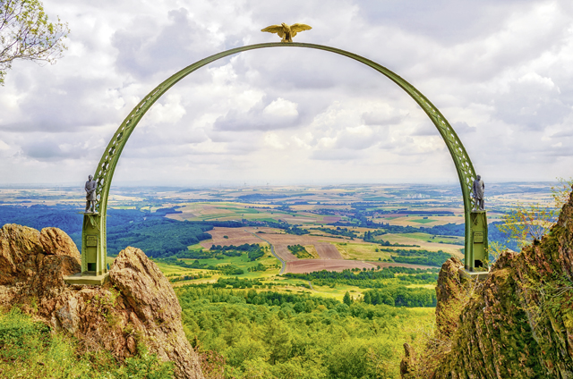
Adlerbogen (Eagle’s Arch)
The monument was erected in 1880 in honor of Field Marshal General von Moltke’s contribution (1800-1891) in securing the Palatinate borders in the Franco-Prussian War (1870/71). It consists of a steel arch crowned by a steel eagle (imperial eagle) and flanked by two statues of Moltke and Bismarck. After World War II, the eagle’s head was shot off by U.S. soldiers in 1945. In 1981, the restored eagle was delivered by helicopter and reinstalled. The Bismarck statue was subsequently perforated and decapitated, while the Moltke statue disappeared completely. As part of another restoration effort, true copies of the two statues were erected on the designated pedestals on June 18, 2016, again flown in by helicopter.
Sports
There is more to Donnersberg than just history. Every year in February, the Donnersberg Run is the first of several races in the Palatinate Mountain Running Cup, covering 7200 meters and a cumulative ascent of 418 meters. The Rockie Mountain Run has also been held at the beginning of April every year since 2010. It leads from the market square in Rockenhausen over about 13 kilometers and 560 meters in altitude to the summit region. The mountain is also popular with mountain bikers. In winter, there are cross-country ski trails on the high elevations, which are groomed at an altitude of around 550 m and have lengths of either 5 or 10 kilometers.
Additionally, Donnersberg is used for paragliding and hang-gliding all year round. Gliders without a motor are launched from the slope. In summer, when the winds are favorable, it is possible to fly from Donnersberg to Saarland or France.
Now, after deeply indulging in history, culture and sports, you must be hungry. No worries, help is on its way in the form of a Celtic hut. The hut, operated by the Palatinate Forest Association, is open on weekends and public holidays, located near the Ludwig Tower parking lots, and offers cake and hearty food.
Donnersberg transmitting tower
At a height of 204.82 meters it is operated by the Südwestrundfunk. It serves as a base network transmitter for FM radio and television and has become a landmark that can be seen from afar. A Defense Communications Station nearby was built for the U.S. Army after World War II, used especially during the Cold War, and played a key role in Germany’s broadcast of the 1969 moon landing, but was shut down 2011.
Fun fact: There is a square dance group with the name Thunderhill Dancers and they are always looking for new dancers.
Whether you are a hiking or biking fan, more into leisurely walks with panoramic views, dance in squares on a round hill or are a history lover, Donnersberg has a lot to offer. Come out and discover for yourself: the mountain is calling!
