
Many a member of the Kaiserslautern Military Community has driven down B40/B37 that runs from Saarbrücken to Mainz. It is referred to as “Kaiserstrasse” in several towns within Kaiserslautern County, such as the main street in Landstuhl. But, did you know that the road plays a significant historical role in the region?
The road was named after the French denomination “Route Impériale,” which means imperial route and was commissioned and completed by Napoleon Bonaparte after being crowned emperor.
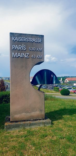
The course of the federal road in Germany stretches from Saarbrücken, via Homburg in Saarland, to Bruchmühlbach, Hauptstuhl, Landstuhl, Kindsbach, Kaiserslautern, Eselsfürth, Mehlingen, Sembach, Wartenberg-Rohrbach, Kirchheimbolanden and Klein-Winternheim to Mainz in an almost perfectly straight line.
An interesting place along the route is near Vogelbach, where the former customs station “Am Zoll” was located, marking the border between Germany and France up until 1957. The road sometimes changes its name enroute, for example to Pariser Strasse (in the west) and Mainzer Strasse (further east) within Kaiserslautern’s city limits.
Up until the end of the 18th century, a fastened road didn’t exist along the western side of the Rhein River. There were a few initiatives to improve the infrastructure that sank into oblivion due to more important issues of the time, while a few partial routes, initially constructed by the Romans, were still used but in a poor condition.
When Napoleon was crowned as “Emperor of the French” in 1804 he traveled to Mainz and per decree declared “Mayence” as one of the 36 most significant cities in France and capital of the Departement Donnersberg. The city had special military significance as a stronghold, and needing to get there quickly and safely, he commissioned construction of the road with the latest technology of the time.
In addition, poplars were planted along both banks of the road to provide shade for the emperor’s soldiers and comfortable travel for Empress Marie-Louise. She adored the city and loved to spend time there, so can you ever do enough to please a woman, even as an emperor?
At the same time, the road leading from Saarbrücken to Paris was upgraded into a French category I prime road, making travel from the French capital to conquered German regions easier. The entire road complex served a further purpose in Napoleon’s goal to conquer the capital of the Prussian Kingdom. Further modern roads were constructed to enable the emperor and his army to march through Brandenburger Tor in Berlin and “kidnap” the Quadriga figure on top in 1806.
A daily postal line developed as a positive effect of the roadway and two stagecoaches rapidly delivered mail and passengers per day. Many of the villages along the road sprang up as resting places with overnight inns, lunch and dinner for the coachmen and fresh water and hay for horses. The so-called “Ritterbau” (knight’s building) passing by Sembach still exists, although in poor condition.
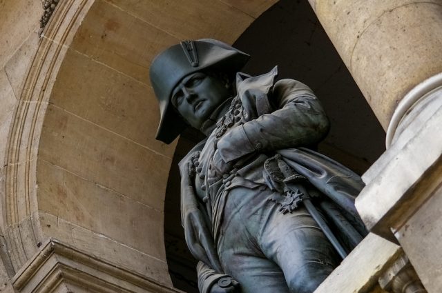
One of Napoleon’s favorite resting places was the Posthalterei in Bruchmühlbach, where he spent the night on several occasions, while he and his entourage received fresh horses. Another prominent inn was located at today’s Mainzer Tor in Kaiserslautern at a building which is now known as “Theodor Zink Museum.” The Kaiserbrunnen at the corner depicts a typical Napoleonic “bicorne” headdress, commemorating the emperor’s travel enroute to Mainz, a 60-kilometer day’s journey at that time.
Rather then taking A63, try out a relaxing trip to Mainz along the old “Kaiserstrasse” and you’ll come across a traffic circle entering Kirchheimbolanden depicting a Napoleon hat. Maybe he rested there under a tree himself one day?
