Being informed before the winter weather hits is a good way to be prepared. Knowing where to find information such as road conditions, early release, late reporting and base and school closures can ensure members of the Kaiserslautern military community keep themselves out of the elements. Following are frequently asked questions with answers.
How are delayed reporting, base closure and early release instructions decided?
The 86th Airlift Wing commander receives a recommendation from the 86th Mission Support Group commander to determine reporting instructions for delayed reporting, early release, or base closure.
Information regarding delayed reporting, early release, and base and school closures for Ramstein Air Base and Vogelweh Military Community can be found at: http://www.ramstein.af.mil/Weather-Info/
Information can also be found on the Ramstein Air Base App, Ramstein Air Base Facebook page, by tuning into the Armed Forces Network radio show at 105.1 FM, or by dialing DSN 480-COLD (2653).
How are school closures decided?
Local schools mirror the status of the installation they are located. Information regarding closures can be found on the Ramstein Air Base App, Ramstein Air Base Facebook page, by tuning into the Armed Forces Network radio show at 105.1 FM, or by dialing DSN 480-COLD (2653).
Where can I find information on delayed reporting, early release, and base and school closures?
Information regarding delayed reporting, early release, and base and school closures for Ramstein Air Base and Vogelweh Military Community can be found at: http://www.ramstein.af.mil/Weather-Info/
Information can also be found on the Ramstein Air Base App, Ramstein Air Base Facebook page, or by dialing DSN 480-COLD (2653).
What should I do if I don’t feel comfortable driving?
Members should stay in contact with their unit leadership or supervisor and are encouraged to make the safe decision based on individual circumstances.
What decides the current ROADCON?
U.S. security forces, military police and weather field reporters pass information to the 86th MSG commander, who recommends the appropriate road condition designation. Each installation commander will determine ROADCON based on their specific location.
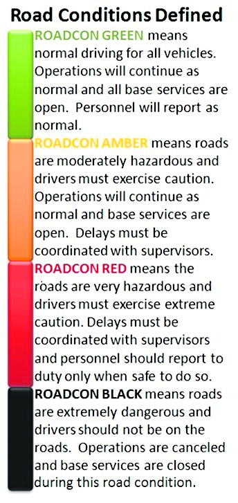
What do the different ROADCONS mean?
GREEN: Road conditions are normal.
AMBER: Road conditions are normal to dangerous. Drivers should exercise additional precautions. Most installation operations and services should be open, but changes in weather could lead to late reporting or early release.
RED: Road conditions are hazardous. Government owned vehicle use off base/post is limited to emergency and mission-essential driving. Privately owned vehicle use is discouraged. Late reporting or early release of personnel and closure of services is probable for non-mission essential personnel.
BLACK: Road conditions are hazardous to extremely hazardous. GOV use off base/post is at the discretion of the owning commander. POVs should not be on the road. Installation Commanders will assess need to close the base, release personnel or delay reporting.
This information can also be found on the winter weather tri-fold pamphlet.
Where do I find the current ROADCONS?
The current ROADCONS for Ramstein Air Base and Vogelweh Military Complex can be found at: http://www.ramstein.af.mil/Weather-Info/.
The ROADCONS for all Army installations in the KMC can be found at: http://www.imcom-europe.army.mil/webs/sites/staff_org/safety/road_conditions/default.aspx, or https://facebook.com/army.rp or ROADCONS will be sent via the AtHoc emergency messaging system.
Information can also be found on the Ramstein Air Base App, Ramstein Air Base Facebook page, by tuning into the Armed Forces Network radio show at 105.1 FM, or by dialing DSN 480-COLD (2653).